
April 4, 2022
Nearly twenty years ago a small group of system and software engineers teamed up to democratize intelligence, surveillance, and reconnaissance with AIMS-ISR.
And just like that, CarteNav was born. For the next two decades, the team at CarteNav have provided ISR excellence for any mission using any sensor on any platform – whether land, sea, or air. It’s just as exciting as it sounds!
You may have seen this Nova Scotian company in the news recently – what started off as a customer flight demonstration suddenly became a real life search and rescue mission. When an emergency call came in reporting 24 migrants distressed off the coast of Belgium, CarteNav’s solutions were truly put to the test. In just 15 minutes after takeoff, the AIMS-ISR management system was able to locate the tiny dingy stranded in the North Sea, saving 24 lives.
Addressing today’s security, safety, economic, and environmental threats across the globe, this team works hard to extend their customers capabilities. Whether their latest mission is with a private agency like Frontex and Heliwest Group, or a national institution such as the National Coast Guard, CarteNav’s mission remains the same – fundamentally enhancing situational awareness across all critical mission operations. Delivering the best results, every time.
After 500 successful installations in over 40 countries, it was clear that maintaining the status-quo was no longer an option for this team of high flyers. In 2020, CarteNav completed the mission data lifecycle with AIMS-C4, and in doing so, created a new standard for real-time and historical mission data distribution in a Common Operating Picture.
CarteNav offers two ISR Mission Software products that together, create a complete mission data lifecycle.
- AIMS-ISR: Their flagship multi-role mission management software
- AIMS-C4: Their ISR data dissemination platform
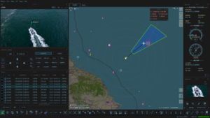

CarteNav’s AIMS-ISR is the actual software allowing the integration of multi-sensor control, geo-referenced moving maps, evidence reporting, SIGINT, custom mapping, and more. AIMS-C4 is an operating picture and advanced communications channel that uses real-time and historical ISR mission data to give operators the insight needed for rapid decision making.
Building a reputation on embracing challenges that others may avoid, CarteNav is driven at the core to gather, simplify, and distribute the essential information for users to achieve their mission. The team’s culture of ambition and pursuit of excellence has allowed them to provide solutions that extend the operator’s capabilities far beyond the industry standard.
Find this exciting? Us too – check out their website to learn a little more about what they do, and how well they really do it!
Since you’re looking, don’t forget about their newly released story and video detailing how a CarteNav flight demonstration became a real-life search and rescue mission, eventually saving the lives of 24 migrants off the coast of Belgium.